Stone Age camps were never random. Every site reveals a precise calculation of wind, water, plants, predators, and sightlines — made by people who read the landscape the way you read a street sign.
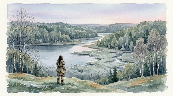
Star Carr, Yorkshire, England. Roughly 9,000 BCE.
A woman stands at the edge of a low ridge where birch forest gives way to reed marsh and the marsh gives way to a wide, still lake. It’s early spring. The birch buds are tight but swelling. Midges aren’t hatching yet — two more warm days, maybe three, and they’ll be unbearable at the water’s edge, but not today. Today the air is clean and cold and smells like wet peat and the faintest green edge of thaw.
She’s been walking since yesterday. The group is behind her — nine adults, four children, everything they own on their backs in rolled hides. They need a camp. Not for a night. For the season.
She looks down at the confluence below and reads it like a page.
The south-facing slope on the far bank catches morning sun and holds warmth past midday — dry ground for sleeping, firewood in reach, limestone outcrop for wind shelter. The reed marsh offers cattail root, bulrush pith, nesting waterfowl and their eggs. The open water holds pike and perch. The birch forest behind the ridge means bark, sap, fungus, and the deer that browse the woodland edge at dusk. Game trails converge at the shallow river crossing — she can see the mud churned by hooves from here. Willow lines the water. Yarrow will be coming up on the open ground in a month.
Water, food, medicine, shelter, fuel, game, sightlines, wind protection. All within a five-minute walk.
She didn’t find this place by accident. She was taught it by her mother, who was taught it by hers. They’ve been coming here since before anyone alive can remember.
When archaeologists excavated Star Carr beginning in 1949, they found one of the richest Mesolithic sites in Europe — a lakeside platform built at exactly the junction of three ecosystems, occupied and reoccupied across centuries. The researchers called the site selection “optimal.” The woman who chose it would have called it obvious.
Why Here? The Logic of Site Selection

One of the most persistent myths about Stone Age people is that they wandered randomly — nomads drifting across an empty landscape, stopping wherever exhaustion or nightfall caught them. The archaeological record tells a completely different story. Prehistoric camps were chosen with a precision that would impress a modern surveyor.
The factors were consistent across tens of thousands of years and thousands of miles, because the physics of survival don’t change.
Wind direction came first. A camp needs fire, and fire needs predictable airflow. You want wind at your back, blowing smoke away from the sleeping area and toward the surrounding landscape — where the smoke serves double duty as an insect repellent and a scent-mask that makes it harder for predators to smell you. A camp placed in a wind tunnel is miserable. A camp in a dead-air hollow fills with smoke and biting insects within hours. The sweet spot is a sheltered position with gentle, consistent airflow — a south-facing slope below a ridge, the lee side of a rock outcrop, a riverbank with prevailing wind running parallel to the water.
Water access mattered, but proximity was a careful calculation. Too close to standing water meant mosquitoes, midges, damp ground, and flooding risk. Too far meant hauling water for drinking, cooking, and hide-processing — exhausting work, especially with children. The ideal was close enough to reach in two or three minutes, far enough to sleep dry and avoid the worst of the insects. Most well-documented Paleolithic and Mesolithic campsites sit between fifty and two hundred meters from their water source. That’s not coincidence. That’s policy.
Elevation provided visibility — you could see what was coming, whether weather, game, or threat — and drainage, which kept sleeping areas dry after rain. Even a modest rise of a few meters above the surrounding terrain made the difference between waking dry and waking in a puddle. Southern exposure in the Northern Hemisphere meant more sunlight hours, faster warming in the morning, and snow that melted earlier in spring. At site after site after site, Paleolithic camps cluster on south-facing or southeast-facing slopes. The pattern is so consistent it’s essentially a rule.
And then there’s the factor that pulls all the others together: what grows nearby. Because camp selection wasn’t just about comfort. It was about pharmacy, pantry, and workshop, all within walking distance.
Choosing a place wasn’t just about safety or water — it quietly determined how everything inside the camp would work: where people slept, where tools were kept, where fire lived and spread.
You can see how those choices shaped daily life in how space was organized inside the camp.
Gathering Places: Where the Plants Grew
A hunting camp can move to follow the game. A gathering camp sits where the plants are, because plants don’t move. And since gathering provided the caloric majority of the diet in most Stone Age societies — estimates range from 60 to 80 percent of total food intake in temperate and tropical environments — the person who knew where the plants grew had the strongest voice in deciding where the group lived.
Different ecosystems offered different resources, and an experienced gatherer read them the way a chef reads a market.
Riverside margins: willow bark for pain relief, cattail for starch and fiber and wound dressing, watercress and water mint in the shallows, sedge for basket-weaving and mat-making. Rivers also meant smooth stones for grinding, clay for pottery or sealant (in later periods), and the fish, crayfish, and freshwater mussels that supplemented lean-season diets.
Forest edges: hazel for nuts — one of the highest-calorie wild foods in temperate Europe — plus berries, bark, fungus, deadfall firewood, birch for tar and sap, and the understory plants that thrive in dappled light: wood sorrel, wild garlic, violets. The forest edge was also where deer browsed at dawn and dusk, making it a convergence zone for both plant gatherers and hunters.
Open grassland and meadow: tubers and roots in spring, seed heads in late summer, yarrow and meadowsweet for medicine, dried grass for bedding and tinder. Open ground also offered sightlines — you could see a storm coming, a herd moving, or a predator approaching from a distance that gave you time to respond.
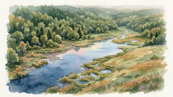
The richest campsites in the archaeological record sit at ecological boundaries — the places where two or three of these zones overlap. Star Carr: lake, marsh, forest. Ohalo II in Israel (23,000 BP): lake shore, grassland, woodland edge. Dolní Věstonice in Moravia (26,000 BP): river floodplain beneath limestone hills. The pattern is universal. Stone Age people camped where the ecosystems converged, because convergence meant maximum resource diversity in minimum travel distance.
And the person who knew which ecosystem held which resource at which time of year — the person who could look at a landscape and see the invisible calendar of ripening, flowering, dying back, returning — was the person who chose the camp.
Sacred and Practical Were the Same Place
Modern people split the world into sacred and secular. Prehistoric people almost certainly didn’t.
Consider springs. A spring is clean water rising from the earth — filtered through stone, cold in summer, warm in winter, reliable when rivers freeze or dry up. In practical terms, a spring is the most valuable water source in a landscape. In experiential terms, a spring is uncanny — water appearing from solid rock, from the ground itself, with no visible source. It’s easy to see how a spring could be simultaneously the best place to camp and the most symbolically powerful feature in the territory.
The same logic applies to caves. A south-facing cave entrance is prime shelter — wind-blocked, dry, thermally stable. It’s also a threshold between the known world and the absolute dark, between daylight and the underground, between the living surface and whatever lies beneath. The practical value and the symbolic power don’t compete. They reinforce each other. A cave is sacred *because* it sustains life. A spring is holy *because* it provides what nothing else can.
Göbekli Tepe, built around 9,600 BCE in southeastern Turkey, is the clearest monumental expression of this principle. Massive carved stone pillars arranged in circles on a hilltop — the oldest known large-scale ritual architecture in the world — built by people who had not yet domesticated a single crop or animal. The hilltop location offered commanding views of the surrounding landscape. Natural springs emerge nearby. Game converged from multiple directions along the valleys below. The site that became the world’s first temple was first and foremost an outstanding campsite. The ritual use didn’t replace the practical logic. It grew out of it.
When Stone Age people returned to the same springs, the same caves, the same hilltop convergence zones generation after generation, they were doing something that looks like both logistics and worship — because for them, there was no gap between the two.
Lake Villages and the Water’s Edge
By the Neolithic period — roughly 5,000 to 2,500 BCE in Central Europe — something remarkable happened at the edges of Alpine lakes in what is now Switzerland, southern Germany, Austria, and northern Italy. People built permanent settlements over the water.
The lake dwellings — *Pfahlbauten* in German — were timber-framed houses built on platforms supported by wooden piles driven into the lakebed. Entire villages of twenty, thirty, fifty houses clustered along the shallow shores of lakes like Constance, Zürich, and Neuchâtel. The waterlogged conditions preserved organic materials that normally rot to nothing: wooden tools, woven textiles, food remains, seeds, even bread. These sites are archaeological treasure chests — UNESCO World Heritage sites today — offering a level of detail about daily Neolithic life that dry-land sites simply can’t match.
But why the water?
The advantages were layered. Lake margins offered the same ecological convergence that drew Mesolithic people to Star Carr — fish, waterfowl, reeds, lakeshore plants, plus the forest and farmland behind. The water itself was a transport route — a canoe moves goods faster and more efficiently than a human back on a forest trail. The lake provided natural defense — an attack from the water side required boats, which meant noise and visibility. Humidity from the lake moderated temperature extremes. And the constant dampness preserved perishable materials in daily use — basketry, cordage, stored grain — better than dry ground.
The lake village wasn’t a primitive hut on stilts. It was a calculated decision to build at the most resource-rich, defensible, and logistically efficient point in the landscape. The people who built them were reading the same variables — water, wind, food, safety, access — that the woman at Star Carr read seven thousand years earlier. The technology changed. The logic didn’t.
She Read the Wind
Here’s what doesn’t show up in the site reports and excavation plans.
Someone had to decide. When the group reached a new valley, or returned to a seasonal territory, or was forced to relocate by flooding or fire or the failure of a food source — someone had to stand on the ridge and read the land and say: here. Not there. Here.
That person needed to hold in their mind simultaneously: where the wind would carry smoke, where the water ran clean, where the ground drained, where the yarrow and willow grew, where the game trails crossed, where the cave bears denned, where the sun hit first in the morning, where the rock face held warmth past sunset, where the children could play within earshot, where the midges would be worst in three weeks when the weather warmed.
That’s not instinct. That’s expertise. It’s environmental science, pharmacology, meteorology, zoology, and risk assessment performed in real time, on foot, by someone carrying an infant and responsible for the survival of fifteen people.
In most documented forager societies, the decision of where to camp involves extensive consultation — but the person whose judgment carries the most weight on matters of plant availability, water quality, and seasonal timing is typically the most experienced woman. Not always. Not by rigid rule. But by the logic of who holds the deepest knowledge of the landscape’s resources across all four seasons.
The woman at Star Carr didn’t command the group. She didn’t need to. She simply knew more about what the land offered and what it threatened than anyone else standing on that ridge. When she pointed to the confluence below the birch forest and said *here*, nobody argued — the same way nobody argues with the navigator who can read the stars.
She wasn’t just choosing a campsite. She was reading a pharmacy, a kitchen, a nursery, a fortress, and a calendar — all written in the same landscape, in a language she’d been learning since she could walk.
They Came Back
Star Carr was occupied and reoccupied for over two hundred years. Generation after generation, people returned to the same lakeside platform, rebuilt it, extended it, burned it, rebuilt it again. The site accumulated layers of worked bone, flint tools, antler headdresses, and charred timber — centuries of returning.
They came back because it worked. The wind still blew from the north. The lake still held fish. The birch still grew on the ridge. The yarrow still came up in the meadow in late spring. The deer still crossed at the shallow ford. Everything the first woman read in the landscape remained true for her granddaughter, and her granddaughter’s granddaughter, and the generations beyond counting who stood on that same ridge and looked down at the same confluence and recognized what it offered.
The knowledge of *why* this place worked was the real infrastructure. Not the timber platform — that rotted and was rebuilt every few decades. The knowledge persisted because someone taught it, and someone learned it, and someone carried it in her head across every winter and every migration and passed it to the next woman who would one day stand on the ridge and read the land.
A good campsite wasn’t just a location — it was a structure waiting to happen.
Once chosen, it defined the rhythm of movement, work, and rest within it.
Next time you choose a seat in a restaurant — back to the wall, facing the door, near the window for light — or pick a campsite, or lay a blanket in a park, notice what you’re scanning for. Sight lines. Shelter. Sun. Wind. Access to what you need, distance from what might threaten you.
You’re running the same assessment she ran. You’ve just forgotten you know how to do it.
She never forgot.
